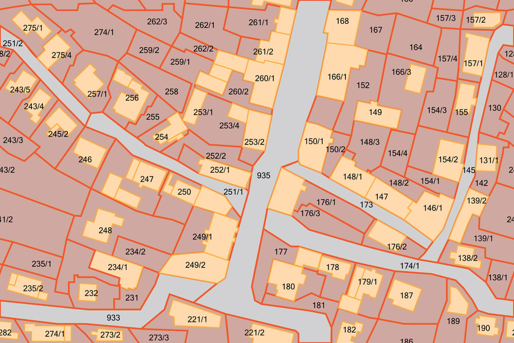
 A plat map shows a piece of land, drawn to scale, with details such as nearby properties, boundaries, land size, flood zones, the surrounding neighborhood, easements, and monuments. When you purchase a home, one of the documents you receive is typically a plat map; reading it can help you make the most out of your investment. Plat maps can look confusing, but with a bit of basic knowledge you can decode yours and use it to your advantage.
What You Can Learn From Reading a Plat Map
Before we dive into reading a plat map, learn why you should utilize this important piece of information. When you purchase a home in Texas and most other states, you’ll receive an official plat map, complete with several numbers and fine print. Although the plat map can appear daunting at first, it can prove invaluable if you know how to decipher it. Civil engineers draw plat maps upon a home’s initial construction. Later, real estate agents use plat maps in transactions as part of title searches. One can gather the following information from a plat map:
- Orientation of the property (north, south, east, or west)
- Easements encroaching on your ownership rights
- Boundary lines of your property
- Designations of roads or public/private rights-of-way
- Dedication of land for public use
- Zoning compliance
Learning how to read a plat map can help you during tasks such as buying or selling real estate, building additions to your property, taking on renovation projects, investing in solar power, and protecting your rights as a landowner. Knowing what your property plat means is a great skill to develop as a property owner, buyer, real estate agent, lawyer, builder, and just in general. Reading a plat map starts with learning the different types of plats.
5 Main Types of Plat Maps
Plat maps, also called land maps or land survey maps, come in a few different types depending on the purpose of the plat and the situation. As a landowner, the type of plat map you receive can vary according to the history of the parcel of land. There are five main types of plat maps you might encounter upon purchasing a piece of land:
- Amending plat. This records small corrections to an existing plat.
- Plat of consolidation. This is done when a single landowner buys several adjacent pieces of land and consolidates them into a single parcel.
- Plat of subdivision. This is a record made when a landowner divides a tract of land into several smaller parcels.
- Short plat. This is used for a subdivision of land into no more than four separate parcels.
- Vacating plat. A plat that legally cancels a prior plat.
Learning the type of plat map that you’re looking at will give you a good foundation as to what you might expect the map to tell you. A plat of subdivision, for example, might have information about the parcel as well as the division of land. From there, you will have to look more closely at the map to distinguish the different numbers, markers, and symbols.
Deciphering the Elements of a Plat Map
First, learn what the many small numbers on a plat map mean. Along the right side of your plat map, you’ll see where the information came from – typically a county assessor. You’ll also see the tract number and often the name the builder has given (if it’s a subdivision). Plat maps list the house number for each parcel, along with the shape of the parcel, or the parcel boundary. The small numbers along the bottom of the parcel is the width, and the number along the right side of the parcel is the depth. Most plat maps have these numbers in feet.
You’ll see the parcel boundary as a straight or dotted line marking the dimensions of the piece of property, as well as separating it from adjacent parcels. The large number in the middle of the property, the one underlined, bolded, and/or italicized, is the parcel number. You might also see the assessor’s parcel number (APN) in the middle of the property. The APN is a number the assessor assigns out of the Assessor’s Book Number. The corners of your plat map will have the book and page number.
The scale of your plat map will be in the map’s legend. The scale will be the ratio between the distance on the map and the distance of the actual property. Use a ruler to get the most accurate reading of your plat map. Some plat maps will provide geographical information of the property, such as exact latitudes and longitudes. If there have been property changes, the plat map will list these as well. Finally, you’ll see any roads on or around your property, clearly outlined and likely with the road name written in its boundary. You should also see private and shared driveways, as well as any roads with easements.
How to Use Your Plat Map
If you’re buying or selling a home, you need to peruse the plat map. Not just anyone can come up with a plat map. It is a legal document that a professional land surveyor must create after establishing boundary lines and assessing the property. The county must sign off on the land survey to make it part of official public record. A plat map is an accurate, unbiased, and trustworthy assessment of a piece of property, if it is based on the most recent and updated land survey.
Use your plat map to double-check the information you received during the transaction of a property. For example, studying the plat map could show you that the house you bought sits on 10,000 square feet, not 6,000 as the previous owner thought. This could lead to more money in your pocket if you decide to sell in the future. It’s also important to know of any easements or public access roads on your property. An easement on your property could mean that others – or the public – can legally use it as they see fit. Seeing an easement in a plat map could influence your decision to purchase a property.
Pro Tips for Reading a Plat Map
Now that you know why you should read a plat map and the basic elements you’ll find on a plat map, you’re ready to hone your skills with a few pro tips. First, find out if you can find your plat map online. Looking at your map online can give you several advantages, such as the ability to zoom in on small print. Once you’ve accessed the most recent plat map of your property, get the most out of reading it with a few additional tips.
Learn the difference between platted and unplatted properties. A platted property is the one a developer creates. Unplatted lots are not recorded subdivisions. For the most part, you’ll find “lot and block” legal descriptions for platted land, but “metes and bounds” measurements for unplatted properties. A metes and bounds measurement might use monuments, angles, or structures to describe a property instead of feet.
Another tip is when in doubt, pay for a land survey. While a plat map can give you a wealth of information about your property, it might not be hyper-accurate or the latest version of events on your land. To get a more in-depth look at a property, hire a land surveyor. A survey is the best way to learn the exact location of boundary lines and other property elements.


